


Sommet et chapelle de Saint-Quinis

frizou83
User
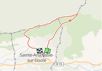

Length
8 km

Max alt
621 m

Uphill gradient
347 m
Km-Effort
12.6 km

Min alt
275 m

Downhill gradient
347 m
Boucle
Yes
Creation date :
2021-09-28 16:40:49.111
Updated on :
2021-09-28 16:41:31.839
2h52
Difficulty : Difficult

FREE GPS app for hiking
 SityTrail
IGN / Geographical institutes
SityTrail Plus
The world is yours!
About
Trail Walking of 8 km to be discovered at Provence-Alpes-Côte d'Azur, Var, Sainte-Anastasie-sur-Issole. This trail is proposed by frizou83.
Positioning
Country:
France
Region :
Provence-Alpes-Côte d'Azur
Department/Province :
Var
Municipality :
Sainte-Anastasie-sur-Issole
Location:
Unknown
Start:(Dec)
Start:(UTM)
267344 ; 4802819 (32T) N.
Comments