


Cargese

jcm17
User
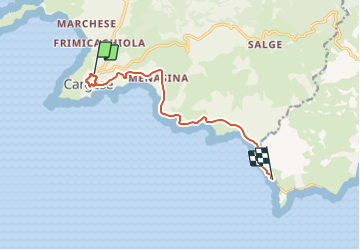

Length
10.2 km

Max alt
94 m

Uphill gradient
139 m
Km-Effort
12.3 km

Min alt
3 m

Downhill gradient
216 m
Boucle
No
Creation date :
2021-09-21 14:22:18.775
Updated on :
2021-09-29 09:42:20.484
1h14
Difficulty : Difficult

FREE GPS app for hiking
 SityTrail
IGN / Geographical institutes
SityTrail Plus
The world is yours!
About
Trail Walking of 10.2 km to be discovered at Corsica, South Corsica, Cargèse. This trail is proposed by jcm17.
Positioning
Country:
France
Region :
Corsica
Department/Province :
South Corsica
Municipality :
Cargèse
Location:
Unknown
Start:(Dec)
Start:(UTM)
466655 ; 4665043 (32T) N.
Comments