


Nice Orly

jcm17
User
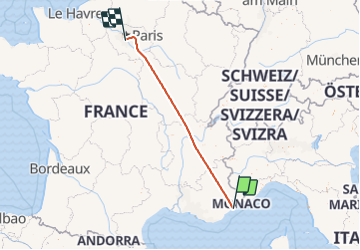

Length
700 km

Max alt
2913 m

Uphill gradient
39600 m
Km-Effort
1228 km

Min alt
29 m

Downhill gradient
39590 m
Boucle
No
Creation date :
2021-09-26 14:46:23.118
Updated on :
2021-09-29 09:42:46.256
1h03
Difficulty : Very easy

FREE GPS app for hiking
 SityTrail
IGN / Geographical institutes
SityTrail Plus
The world is yours!
About
Trail Plane of 700 km to be discovered at Provence-Alpes-Côte d'Azur, Maritime Alps, Antibes. This trail is proposed by jcm17.
Positioning
Country:
France
Region :
Provence-Alpes-Côte d'Azur
Department/Province :
Maritime Alps
Municipality :
Antibes
Location:
Unknown
Start:(Dec)
Start:(UTM)
346653 ; 4828770 (32T) N.
Comments