


chateauneuf du pape

aupi
User
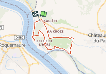

Length
7.8 km

Max alt
43 m

Uphill gradient
73 m
Km-Effort
8.7 km

Min alt
21 m

Downhill gradient
71 m
Boucle
Yes
Creation date :
2021-09-28 12:13:38.86
Updated on :
2021-10-01 02:40:00.518
3h03
Difficulty : Easy

FREE GPS app for hiking
 SityTrail
IGN / Geographical institutes
SityTrail Plus
The world is yours!
About
Trail Walking of 7.8 km to be discovered at Provence-Alpes-Côte d'Azur, Vaucluse, Châteauneuf-du-Pape. This trail is proposed by aupi.
Positioning
Country:
France
Region :
Provence-Alpes-Côte d'Azur
Department/Province :
Vaucluse
Municipality :
Châteauneuf-du-Pape
Location:
Unknown
Start:(Dec)
Start:(UTM)
643750 ; 4880387 (31T) N.
Comments