


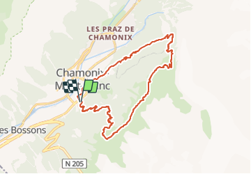
Plan aiguille + mer de glace

Airelle
User

Length
19.2 km

Max alt
2247 m

Uphill gradient
1358 m
Km-Effort
37 km

Min alt
1033 m

Downhill gradient
1380 m
Boucle
Yes
Creation date :
2021-09-30 07:15:45.0
Updated on :
2021-09-30 18:29:09.717
7h22
Difficulty : Very difficult

FREE GPS app for hiking
 SityTrail
IGN / Geographical institutes
SityTrail Plus
The world is yours!
About
Trail Walking of 19.2 km to be discovered at Auvergne-Rhône-Alpes, Upper Savoy, Chamonix-Mont-Blanc. This trail is proposed by Airelle.
Positioning
Country:
France
Region :
Auvergne-Rhône-Alpes
Department/Province :
Upper Savoy
Municipality :
Chamonix-Mont-Blanc
Location:
Unknown
Start:(Dec)
Start:(UTM)
334995 ; 5086999 (32T) N.
Comments