


autour de culles les roches

XavierFaidix
User
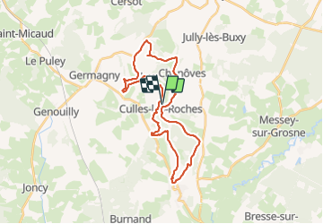

Length
30 km

Max alt
439 m

Uphill gradient
789 m
Km-Effort
41 km

Min alt
233 m

Downhill gradient
790 m
Boucle
Yes
Creation date :
2021-09-30 11:30:10.827
Updated on :
2021-09-30 19:10:43.277
3h00
Difficulty : Medium

FREE GPS app for hiking
 SityTrail
IGN / Geographical institutes
SityTrail Plus
The world is yours!
About
Trail Mountain bike of 30 km to be discovered at Bourgogne-Franche-Comté, Saône-et-Loire, Culles-les-Roches. This trail is proposed by XavierFaidix.
Positioning
Country:
France
Region :
Bourgogne-Franche-Comté
Department/Province :
Saône-et-Loire
Municipality :
Culles-les-Roches
Location:
Unknown
Start:(Dec)
Start:(UTM)
626648 ; 5168196 (31T) N.
Comments