


cotignac

clintest
User
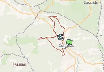

Length
15.2 km

Max alt
479 m

Uphill gradient
426 m
Km-Effort
21 km

Min alt
222 m

Downhill gradient
343 m
Boucle
No
Creation date :
2021-10-01 07:41:31.414
Updated on :
2022-03-09 19:52:06.172
4h41
Difficulty : Medium
4h41
Difficulty : Very difficult

FREE GPS app for hiking
 SityTrail
IGN / Geographical institutes
SityTrail Plus
The world is yours!
About
Trail On foot of 15.2 km to be discovered at Provence-Alpes-Côte d'Azur, Var, Cotignac. This trail is proposed by clintest.
Positioning
Country:
France
Region :
Provence-Alpes-Côte d'Azur
Department/Province :
Var
Municipality :
Cotignac
Location:
Unknown
Start:(Dec)
Start:(UTM)
269621 ; 4823094 (32T) N.
Comments