


Entre Bun et Sireix

micheldutilleul
User
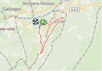

Length
5.5 km

Max alt
917 m

Uphill gradient
203 m
Km-Effort
8.2 km

Min alt
728 m

Downhill gradient
201 m
Boucle
Yes
Creation date :
2021-10-01 08:03:52.566
Updated on :
2021-10-01 10:28:21.005
1h29
Difficulty : Easy

FREE GPS app for hiking
 SityTrail
IGN / Geographical institutes
SityTrail Plus
The world is yours!
About
Trail Walking of 5.5 km to be discovered at Occitania, Hautespyrenees, Bun. This trail is proposed by micheldutilleul.
Positioning
Country:
France
Region :
Occitania
Department/Province :
Hautespyrenees
Municipality :
Bun
Location:
Unknown
Start:(Dec)
Start:(UTM)
731632 ; 4761652 (30T) N.
Comments