


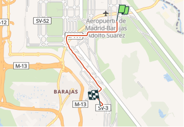
roulage sol Mad

jmheydorff
User

Length
4.3 km

Max alt
615 m

Uphill gradient
51 m
Km-Effort
4.9 km

Min alt
588 m

Downhill gradient
36 m
Boucle
No
Creation date :
2021-10-01 14:28:33.738
Updated on :
2021-10-01 14:38:02.03
7m
Difficulty : Very easy

FREE GPS app for hiking
 SityTrail
IGN / Geographical institutes
SityTrail Plus
The world is yours!
About
Trail Plane of 4.3 km to be discovered at Community of Madrid, Unknown, Madrid. This trail is proposed by jmheydorff.
Positioning
Country:
Spain
Region :
Community of Madrid
Department/Province :
Unknown
Municipality :
Madrid
Location:
Barajas
Start:(Dec)
Start:(UTM)
452327 ; 4482475 (30T) N.
Comments