


Rando G4: Col de la Colombiere

jlrayon
User


4h08
Difficulty : Difficult

FREE GPS app for hiking
 SityTrail
IGN / Geographical institutes
SityTrail Plus
The world is yours!
About
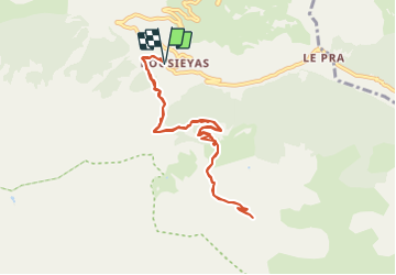
Trail Walking of 9.5 km to be discovered at Provence-Alpes-Côte d'Azur, Maritime Alps, Saint-Dalmas-le-Selvage. This trail is proposed by jlrayon.
Description
De Bousiéyas, Saint-Dalmas-le-Selvage au Col de la Colombière
Trace de la Rando du groupe G4 effectuée le vendredi 1 octobre 2021 de 09:34 à 15:37
Temps total : 06h03m20s
Temps de marche : 04h39m51s
Temps de pause : 01h23m29s
Positioning
Comments