


St_Verand_1

daniellebou
User
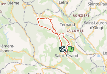

Length
10.9 km

Max alt
663 m

Uphill gradient
395 m
Km-Effort
16.2 km

Min alt
370 m

Downhill gradient
394 m
Boucle
Yes
Creation date :
2021-10-01 21:02:00.562
Updated on :
2021-10-01 21:04:18.867
3h40
Difficulty : Difficult

FREE GPS app for hiking
 SityTrail
IGN / Geographical institutes
SityTrail Plus
The world is yours!
About
Trail Walking of 10.9 km to be discovered at Auvergne-Rhône-Alpes, Rhône, Saint-Vérand. This trail is proposed by daniellebou.
Positioning
Country:
France
Region :
Auvergne-Rhône-Alpes
Department/Province :
Rhône
Municipality :
Saint-Vérand
Location:
Unknown
Start:(Dec)
Start:(UTM)
618493 ; 5086192 (31T) N.
Comments
Très belle Randonnée assez longue en raison du denivelle