


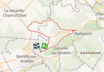
Pont St Pierre: Boucle par Radepont

JMCMoreau
User

Length
13.2 km

Max alt
156 m

Uphill gradient
208 m
Km-Effort
16 km

Min alt
12 m

Downhill gradient
208 m
Boucle
Yes
Creation date :
2021-10-02 08:00:55.671
Updated on :
2021-10-02 08:02:47.623
4h00
Difficulty : Easy

FREE GPS app for hiking
 SityTrail
IGN / Geographical institutes
SityTrail Plus
The world is yours!
About
Trail Walking of 13.2 km to be discovered at Normandy, Eure, Pont-Saint-Pierre. This trail is proposed by JMCMoreau.
Positioning
Country:
France
Region :
Normandy
Department/Province :
Eure
Municipality :
Pont-Saint-Pierre
Location:
Unknown
Start:(Dec)
Start:(UTM)
374688 ; 5466292 (31U) N.
Comments