


décollage Mad Fuerte

jmheydorff
User

Length
154 km

Max alt
810 m

Uphill gradient
2482 m
Km-Effort
187 km

Min alt
467 m

Downhill gradient
2282 m
Boucle
No
Creation date :
2021-10-02 05:57:16.974
Updated on :
2021-10-02 08:21:33.435
22m
Difficulty : Very easy

FREE GPS app for hiking
 SityTrail
IGN / Geographical institutes
SityTrail Plus
The world is yours!
About
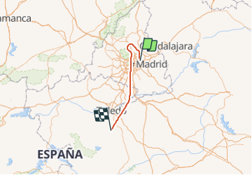
Trail Plane of 154 km to be discovered at Community of Madrid, Unknown, Madrid. This trail is proposed by jmheydorff.
Positioning
Country:
Spain
Region :
Community of Madrid
Department/Province :
Unknown
Municipality :
Madrid
Location:
Barajas
Start:(Dec)
Start:(UTM)
451625 ; 4478990 (30T) N.
Comments