


pauligne la moneze malras

christinetondeur
User
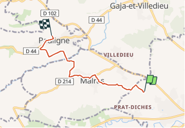

Length
4.9 km

Max alt
256 m

Uphill gradient
94 m
Km-Effort
6.1 km

Min alt
198 m

Downhill gradient
100 m
Boucle
No
Creation date :
2021-10-01 12:52:22.784
Updated on :
2021-10-02 08:34:53.793
1h18
Difficulty : Very easy

FREE GPS app for hiking
 SityTrail
IGN / Geographical institutes
SityTrail Plus
The world is yours!
About
Trail Walking of 4.9 km to be discovered at Occitania, Aude, Limoux. This trail is proposed by christinetondeur.
Positioning
Country:
France
Region :
Occitania
Department/Province :
Aude
Municipality :
Limoux
Location:
Unknown
Start:(Dec)
Start:(UTM)
434061 ; 4767830 (31T) N.
Comments