


Aghifaranga

GOHIER
User

Length
25 km

Max alt
276 m

Uphill gradient
665 m
Km-Effort
34 km

Min alt
5 m

Downhill gradient
679 m
Boucle
No
Creation date :
2021-10-03 06:57:36.0
Updated on :
2021-10-03 13:04:03.162
5h29
Difficulty : Very difficult

FREE GPS app for hiking
 SityTrail
IGN / Geographical institutes
SityTrail Plus
The world is yours!
About
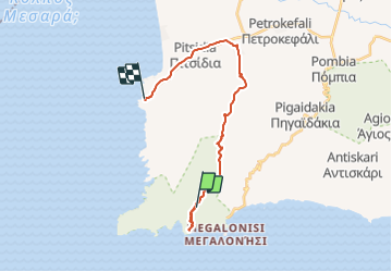
Trail Walking of 25 km to be discovered at Region of Crete, Heraklion Regional Unit, Municipality of Pigaidakia. This trail is proposed by GOHIER.
Description
Court et plat
Positioning
Country:
Greece
Region :
Region of Crete
Department/Province :
Heraklion Regional Unit
Municipality :
Municipality of Pigaidakia
Location:
Unknown
Start:(Dec)
Start:(UTM)
297394 ; 3868320 (35S) N.
Comments