


parilly goudron 05 10 21_ 6.1

jtraverse
User
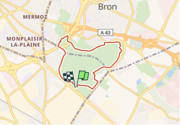

Length
6.1 km

Max alt
218 m

Uphill gradient
69 m
Km-Effort
7 km

Min alt
182 m

Downhill gradient
69 m
Boucle
Yes
Creation date :
2021-10-05 06:47:32.352
Updated on :
2021-10-05 08:23:27.918
1h16
Difficulty : Medium

FREE GPS app for hiking
 SityTrail
IGN / Geographical institutes
SityTrail Plus
The world is yours!
About
Trail Walking of 6.1 km to be discovered at Auvergne-Rhône-Alpes, Métropole de Lyon, Vénissieux. This trail is proposed by jtraverse.
Positioning
Country:
France
Region :
Auvergne-Rhône-Alpes
Department/Province :
Métropole de Lyon
Municipality :
Vénissieux
Location:
Unknown
Start:(Dec)
Start:(UTM)
647777 ; 5064068 (31T) N.
Comments