


villeherviers

lecmic
User
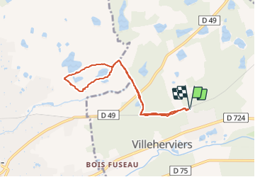

Length
7.2 km

Max alt
107 m

Uphill gradient
45 m
Km-Effort
7.8 km

Min alt
92 m

Downhill gradient
45 m
Boucle
Yes
Creation date :
2021-10-06 12:16:31.207
Updated on :
2021-10-06 14:10:19.306
1h53
Difficulty : Very easy

FREE GPS app for hiking
 SityTrail
IGN / Geographical institutes
SityTrail Plus
The world is yours!
About
Trail Walking of 7.2 km to be discovered at Centre-Loire Valley, Loir-et-Cher, Villeherviers. This trail is proposed by lecmic.
Description
rando santé
Positioning
Country:
France
Region :
Centre-Loire Valley
Department/Province :
Loir-et-Cher
Municipality :
Villeherviers
Location:
Unknown
Start:(Dec)
Start:(UTM)
409179 ; 5246890 (31T) N.
Comments