


camp redon

vincente204
User
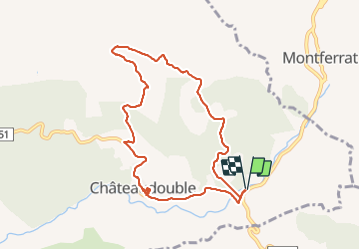

Length
9.3 km

Max alt
601 m

Uphill gradient
253 m
Km-Effort
12.7 km

Min alt
430 m

Downhill gradient
254 m
Boucle
Yes
Creation date :
2021-10-06 11:56:27.948
Updated on :
2021-10-06 14:40:38.378
2h42
Difficulty : Difficult

FREE GPS app for hiking
 SityTrail
IGN / Geographical institutes
SityTrail Plus
The world is yours!
About
Trail Walking of 9.3 km to be discovered at Provence-Alpes-Côte d'Azur, Var, Châteaudouble. This trail is proposed by vincente204.
Description
facile
Positioning
Country:
France
Region :
Provence-Alpes-Côte d'Azur
Department/Province :
Var
Municipality :
Châteaudouble
Location:
Unknown
Start:(Dec)
Start:(UTM)
295706 ; 4830147 (32T) N.
Comments