


siou blanc

affinetataille
User GUIDE
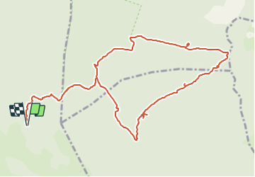

Length
13.3 km

Max alt
733 m

Uphill gradient
318 m
Km-Effort
17.6 km

Min alt
540 m

Downhill gradient
318 m
Boucle
Yes
Creation date :
2021-10-06 07:27:51.385
Updated on :
2021-10-06 17:49:38.489
4h00
Difficulty : Medium

FREE GPS app for hiking
 SityTrail
IGN / Geographical institutes
SityTrail Plus
The world is yours!
About
Trail Walking of 13.3 km to be discovered at Provence-Alpes-Côte d'Azur, Var, Signes. This trail is proposed by affinetataille.
Positioning
Country:
France
Region :
Provence-Alpes-Côte d'Azur
Department/Province :
Var
Municipality :
Signes
Location:
Unknown
Start:(Dec)
Start:(UTM)
737223 ; 4790530 (31T) N.
Comments