


Couyras

pb07
User
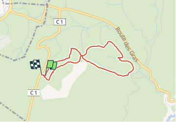

Length
3.7 km

Max alt
266 m

Uphill gradient
62 m
Km-Effort
4.6 km

Min alt
217 m

Downhill gradient
63 m
Boucle
Yes
Creation date :
2021-10-06 14:06:47.857
Updated on :
2021-10-06 16:51:51.349
2h44
Difficulty : Easy

FREE GPS app for hiking
 SityTrail
IGN / Geographical institutes
SityTrail Plus
The world is yours!
About
Trail Walking of 3.7 km to be discovered at Auvergne-Rhône-Alpes, Ardèche, Balazuc. This trail is proposed by pb07.
Positioning
Country:
France
Region :
Auvergne-Rhône-Alpes
Department/Province :
Ardèche
Municipality :
Balazuc
Location:
Unknown
Start:(Dec)
Start:(UTM)
606866 ; 4929901 (31T) N.
Comments