


cretes de cabrières - variante

Giraud34
User
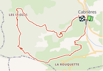

Length
14.6 km

Max alt
363 m

Uphill gradient
540 m
Km-Effort
22 km

Min alt
102 m

Downhill gradient
542 m
Boucle
Yes
Creation date :
2021-10-06 18:41:14.116
Updated on :
2024-12-11 17:21:39.13
4h57
Difficulty : Very difficult

FREE GPS app for hiking
 SityTrail
IGN / Geographical institutes
SityTrail Plus
The world is yours!
About
Trail Walking of 14.6 km to be discovered at Occitania, Hérault, Cabrières. This trail is proposed by Giraud34.

Positioning
Country:
France
Region :
Occitania
Department/Province :
Hérault
Municipality :
Cabrières
Location:
Unknown
Start:(Dec)
Start:(UTM)
529349 ; 4824476 (31T) N.
Comments