


Huhnelmuhle-Belle Vue

GR5 2020
User
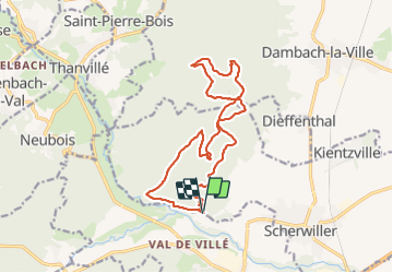

Length
15.6 km

Max alt
656 m

Uphill gradient
560 m
Km-Effort
23 km

Min alt
200 m

Downhill gradient
558 m
Boucle
Yes
Creation date :
2021-10-07 12:18:16.373
Updated on :
2021-10-07 14:49:09.67
2h30
Difficulty : Very easy

FREE GPS app for hiking
 SityTrail
IGN / Geographical institutes
SityTrail Plus
The world is yours!
About
Trail Trail of 15.6 km to be discovered at Grand Est, Bas-Rhin, Scherwiller. This trail is proposed by GR5 2020.
Positioning
Country:
France
Region :
Grand Est
Department/Province :
Bas-Rhin
Municipality :
Scherwiller
Location:
Unknown
Start:(Dec)
Start:(UTM)
380503 ; 5349794 (32U) N.
Comments