


Virigni

papajp
User
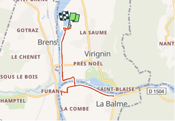

Length
8.7 km

Max alt
228 m

Uphill gradient
48 m
Km-Effort
9.3 km

Min alt
219 m

Downhill gradient
45 m
Boucle
Yes
Creation date :
2021-10-07 13:00:11.0
Updated on :
2021-10-07 14:51:08.522
47m
Difficulty : Unknown

FREE GPS app for hiking
 SityTrail
IGN / Geographical institutes
SityTrail Plus
The world is yours!
About
Trail Electric bike of 8.7 km to be discovered at Auvergne-Rhône-Alpes, Ain, Virignin. This trail is proposed by papajp.
Positioning
Country:
France
Region :
Auvergne-Rhône-Alpes
Department/Province :
Ain
Municipality :
Virignin
Location:
Unknown
Start:(Dec)
Start:(UTM)
710305 ; 5066940 (31T) N.
Comments