


Rando-Octobre-Rose 8km 2021

VANDERPUTTENMi
User GUIDE
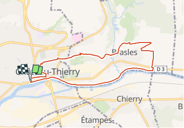

Length
8.5 km

Max alt
125 m

Uphill gradient
121 m
Km-Effort
10.1 km

Min alt
56 m

Downhill gradient
121 m
Boucle
Yes
Creation date :
2021-10-08 11:20:05.035
Updated on :
2021-10-10 16:49:44.071
2h17
Difficulty : Medium

FREE GPS app for hiking
 SityTrail
IGN / Geographical institutes
SityTrail Plus
The world is yours!
About
Trail Walking of 8.5 km to be discovered at Hauts-de-France, Aisne, Château-Thierry. This trail is proposed by VANDERPUTTENMi.
Photos

Positioning
Country:
France
Region :
Hauts-de-France
Department/Province :
Aisne
Municipality :
Château-Thierry
Location:
Unknown
Start:(Dec)
Start:(UTM)
529008 ; 5432385 (31U) N.
Comments