Trail Nordic walking Lanfains - Autour de Lanfain - Photo
 yago1404
yago1404

User

© OpenStreetMap contributors
Length
Length
11 km
Max alt
Max alt
320 m
Uphill gradient
Uphill gradient
187 m
Km-Effort
Km-Effort  
13.5 km
Min alt
Min alt
233 m
Downhill gradient
Downhill gradient
186 m
Boucle
Boucle
Yes
Creation date :
2021-10-08 11:55:12.0
Updated on :
2021-10-08 14:58:35.331

(0 Reviews)

Nordic walking
Nordic walking
2h42
Difficulty : Medium

Scan this QR Code to open this trail in the SityTrail application

FREE GPS app for hiking

Logo SityTrail SityTrail

IGN / Geographical institutes

Download SityTrail from the App Store Download SityTrail from Google Play

Logo SityTrail SityTrail World

The world is yours!

Download SityTrail from the App Store Download SityTrail from Google Play Download SityTrail on Huawei AppGallery

About

Trail Nordic walking of 11 km to be discovered at Brittany, Côtes-d'Armor, Lanfains. This trail is proposed by yago1404.

Description

Belle découverte de la commune la plus haut située de Bretagne

Elevation profile

Photos

Positioning

Country:
France
Region :
Brittany
Department/Province :
Côtes-d'Armor
Municipality :
Lanfains
Location:
Unknown
Start:(UTM)
506405 ; 5355487 (30U) N.

Trails nearby

Trail Walking Saint-Brandan - tenault - Photo
Walking
RLG

Walking

Easy
Saint-Brandan, Brittany, Côtes-d'Armor, France
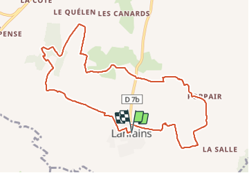
3.1 km | 3.8 km-effort
1h 30min
No
Trail Walking Le Bodéo - bosmeleac oust - Photo
Walking
Bebbeb

Walking

Medium
Le Bodéo, Brittany, Côtes-d'Armor, France
7.9 km | 9 km-effort
2h 8min
Yes


Close
My subscriptions