


Denivelé autour d'hautpoul

Dupleix
User
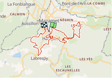

Length
24 km

Max alt
678 m

Uphill gradient
1393 m
Km-Effort
43 km

Min alt
277 m

Downhill gradient
1392 m
Boucle
Yes
Creation date :
2021-10-08 15:48:59.916
Updated on :
2021-10-08 15:50:09.229
9h44
Difficulty : Very difficult

FREE GPS app for hiking
 SityTrail
IGN / Geographical institutes
SityTrail Plus
The world is yours!
About
Trail On foot of 24 km to be discovered at Occitania, Tarn, Mazamet. This trail is proposed by Dupleix.
Description
Boucle tres dure
Positioning
Country:
France
Region :
Occitania
Department/Province :
Tarn
Municipality :
Mazamet
Location:
Unknown
Start:(Dec)
Start:(UTM)
449576 ; 4814412 (31T) N.
Comments