


Villars

elcanario
User
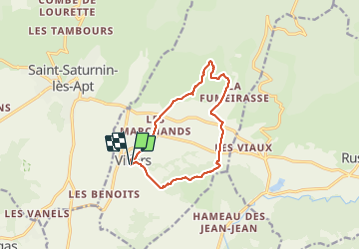

Length
11.7 km

Max alt
545 m

Uphill gradient
378 m
Km-Effort
16.8 km

Min alt
279 m

Downhill gradient
374 m
Boucle
Yes
Creation date :
2021-10-09 11:03:56.055
Updated on :
2021-10-09 16:12:54.612
5h08
Difficulty : Easy

FREE GPS app for hiking
 SityTrail
IGN / Geographical institutes
SityTrail Plus
The world is yours!
About
Trail Walking of 11.7 km to be discovered at Provence-Alpes-Côte d'Azur, Vaucluse, Villars. This trail is proposed by elcanario.
Positioning
Country:
France
Region :
Provence-Alpes-Côte d'Azur
Department/Province :
Vaucluse
Municipality :
Villars
Location:
Unknown
Start:(Dec)
Start:(UTM)
693060 ; 4866065 (31T) N.
Comments