


Messigny et Vantoux

daco21
User
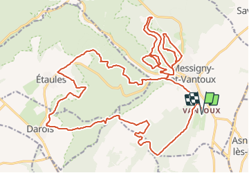

Length
35 km

Max alt
520 m

Uphill gradient
825 m
Km-Effort
46 km

Min alt
287 m

Downhill gradient
825 m
Boucle
Yes
Creation date :
2021-10-09 19:50:27.93
Updated on :
2021-10-09 19:56:14.685
2h54
Difficulty : Very difficult

FREE GPS app for hiking
 SityTrail
IGN / Geographical institutes
SityTrail Plus
The world is yours!
About
Trail Mountain bike of 35 km to be discovered at Bourgogne-Franche-Comté, Côte-d'Or, Messigny-et-Vantoux. This trail is proposed by daco21.
Positioning
Country:
France
Region :
Bourgogne-Franche-Comté
Department/Province :
Côte-d'Or
Municipality :
Messigny-et-Vantoux
Location:
Unknown
Start:(Dec)
Start:(UTM)
652472 ; 5251049 (31T) N.
Comments