


2021-10-10 raid extrême 91 réalisé

Lucquiaud
User
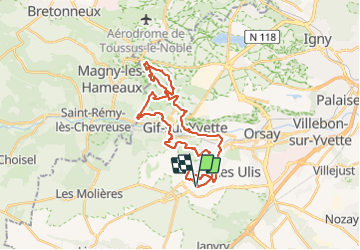

Length
33 km

Max alt
171 m

Uphill gradient
943 m
Km-Effort
46 km

Min alt
58 m

Downhill gradient
942 m
Boucle
Yes
Creation date :
2021-10-10 05:53:39.284
Updated on :
2021-10-10 13:05:03.218
7h10
Difficulty : Very difficult

FREE GPS app for hiking
 SityTrail
IGN / Geographical institutes
SityTrail Plus
The world is yours!
About
Trail Walking of 33 km to be discovered at Ile-de-France, Essonne, Gometz-le-Châtel. This trail is proposed by Lucquiaud.
Positioning
Country:
France
Region :
Ile-de-France
Department/Province :
Essonne
Municipality :
Gometz-le-Châtel
Location:
Unknown
Start:(Dec)
Start:(UTM)
436845 ; 5391671 (31U) N.
Comments