Trail Walking Guillestre - col garnies aller retour  - Photo
 tchoua
tchoua

User

© OpenStreetMap contributors
Length
Length
19.5 km
Max alt
Max alt
2268 m
Uphill gradient
Uphill gradient
1441 m
Km-Effort
Km-Effort  
39 km
Min alt
Min alt
1064 m
Downhill gradient
Downhill gradient
1433 m
Boucle
Boucle
Yes
Creation date :
2021-10-10 08:20:50.491
Updated on :
2021-10-10 14:13:00.141

(0 Reviews)

Walking
Walking
4h47
Difficulty : Medium

Scan this QR Code to open this trail in the SityTrail application

FREE GPS app for hiking

Logo SityTrail SityTrail

IGN / Geographical institutes

Download SityTrail from the App Store Download SityTrail from Google Play

Logo SityTrail SityTrail World

The world is yours!

Download SityTrail from the App Store Download SityTrail from Google Play Download SityTrail on Huawei AppGallery

About

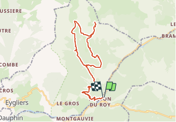
Trail Walking of 19.5 km to be discovered at Provence-Alpes-Côte d'Azur, Hautes-Alpes, Guillestre. This trail is proposed by tchoua.

Description

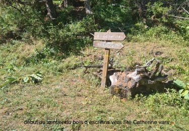
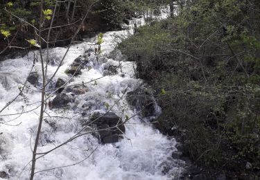
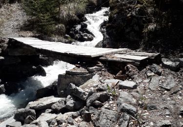
attention sentier rive droite depuis la cabane valette dangereux effondrement des rives dans la traversée des rious le sentier est coupé à différents endroits redescendre par l itinéraire principal

Elevation profile

Photos

Positioning

Country:
France
Region :
Provence-Alpes-Côte d'Azur
Department/Province :
Hautes-Alpes
Municipality :
Guillestre
Location:
Unknown
Start:(UTM)
317357 ; 4949882 (32T) N.

Trails nearby

Trail Walking Guillestre - Rue des Masques - Photo
Walking
Dervalmarc

Walking

Very easy
(1)
Guillestre, Provence-Alpes-Côte d'Azur, Hautes-Alpes, France
5.1 km | 7.9 km-effort
1h 47min
Yes
Trail Walking Eygliers - crots les Girars - Photo
Walking
Sorriaux

Walking

Medium
(1)
Eygliers, Provence-Alpes-Côte d'Azur, Hautes-Alpes, France
10.2 km | 16.9 km-effort
3h 41min
Yes
Trail Walking Guillestre - guillestre, rif bel,col de la scie, crete de vars,la coulette et retour par riou bel - Photo
Walking
tchoua

Walking

Very difficult
Guillestre, Provence-Alpes-Côte d'Azur, Hautes-Alpes, France
24 km | 45 km-effort
6h 24min
Yes
Trail Walking Guillestre - cugulet aller retour  - Photo
Walking
tchoua

Walking

Medium
Guillestre, Provence-Alpes-Côte d'Azur, Hautes-Alpes, France
14.6 km | 33 km-effort
4h 2min
Yes
Trail Walking Guillestre - Roche Rousse et Rocher de l'aigle  à  Guillestre  - Photo
Walking
Sorriaux

Walking

Medium
Guillestre, Provence-Alpes-Côte d'Azur, Hautes-Alpes, France
8.6 km | 14 km-effort
2h 52min
Yes
Trail Walking Eygliers - Gros  cabannes Tourouder - Photo
Walking
Sorriaux

Walking

Medium
Eygliers, Provence-Alpes-Côte d'Azur, Hautes-Alpes, France
14.7 km | 27 km-effort
4h 32min
Yes
Trail Sled dogs Guillestre -  Charmousse. Ceillac  - Photo
Sled dogs
jeff2

Sled dogs

Difficult
Guillestre, Provence-Alpes-Côte d'Azur, Hautes-Alpes, France
9.9 km | 20 km-effort
3h 51min
No
Trail Walking Risoul - Le Villaret  plan Phazy - Photo
Walking
Sorriaux

Walking

Medium
Risoul, Provence-Alpes-Côte d'Azur, Hautes-Alpes, France
10.9 km | 16.5 km-effort
3h 11min
Yes
Trail Walking Guillestre - Le Villaret Barbein - Photo
Walking
Sorriaux

Walking

Medium
Guillestre, Provence-Alpes-Côte d'Azur, Hautes-Alpes, France
10.2 km | 16.2 km-effort
3h 7min
Yes


Close
My subscriptions