


Jumelles Monoblet1

ARVIEU
User
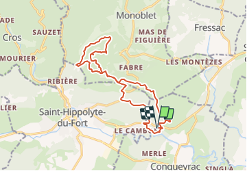

Length
17 km

Max alt
498 m

Uphill gradient
565 m
Km-Effort
25 km

Min alt
139 m

Downhill gradient
565 m
Boucle
Yes
Creation date :
2021-10-11 06:00:04.934
Updated on :
2021-10-11 06:01:28.354
5h00
Difficulty : Medium

FREE GPS app for hiking
 SityTrail
IGN / Geographical institutes
SityTrail Plus
The world is yours!
About
Trail Walking of 17 km to be discovered at Occitania, Gard, Conqueyrac. This trail is proposed by ARVIEU.
Positioning
Country:
France
Region :
Occitania
Department/Province :
Gard
Municipality :
Conqueyrac
Location:
Unknown
Start:(Dec)
Start:(UTM)
572134 ; 4867879 (31T) N.
Comments