


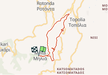
Tour de Stavros + Kastelli 605 m alt.

GOHIER
User

Length
8.7 km

Max alt
566 m

Uphill gradient
390 m
Km-Effort
13.9 km

Min alt
266 m

Downhill gradient
382 m
Boucle
Yes
Creation date :
2021-10-11 08:24:52.0
Updated on :
2021-10-11 12:09:37.489
3h43
Difficulty : Easy

FREE GPS app for hiking
 SityTrail
IGN / Geographical institutes
SityTrail Plus
The world is yours!
About
Trail Walking of 8.7 km to be discovered at Region of Crete, Chania Regional Unit. This trail is proposed by GOHIER.
Description
Un peu routier
Positioning
Country:
Greece
Region :
Region of Crete
Department/Province :
Chania Regional Unit
Municipality :
Unknown
Location:
Unknown
Start:(Dec)
Start:(UTM)
741895 ; 3922060 (34S) N.
Comments