


boucle Rott

Lychee
User
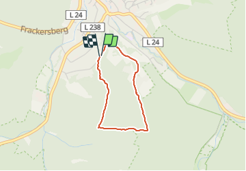

Length
2.3 km

Max alt
376 m

Uphill gradient
77 m
Km-Effort
3.4 km

Min alt
296 m

Downhill gradient
78 m
Boucle
Yes
Creation date :
2021-10-11 13:25:11.778
Updated on :
2021-10-11 14:07:42.936
38m
Difficulty : Easy

FREE GPS app for hiking
 SityTrail
IGN / Geographical institutes
SityTrail Plus
The world is yours!
About
Trail Walking of 2.3 km to be discovered at North Rhine-Westphalia, Städteregion Aachen, Stolberg. This trail is proposed by Lychee.
Positioning
Country:
Germany
Region :
North Rhine-Westphalia
Department/Province :
Städteregion Aachen
Municipality :
Stolberg
Location:
Unknown
Start:(Dec)
Start:(UTM)
306311 ; 5621697 (32U) N.
Comments