


Le tour du CRASH

Clo0413
User
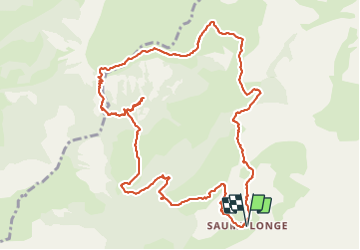

Length
13.2 km

Max alt
1842 m

Uphill gradient
696 m
Km-Effort
22 km

Min alt
1345 m

Downhill gradient
700 m
Boucle
Yes
Creation date :
2021-10-11 07:27:30.085
Updated on :
2021-10-11 20:46:31.876
4h10
Difficulty : Difficult

FREE GPS app for hiking
 SityTrail
IGN / Geographical institutes
SityTrail Plus
The world is yours!
About
Trail Walking of 13.2 km to be discovered at Provence-Alpes-Côte d'Azur, Alpes-de-Haute-Provence, Prads-Haute-Bléone. This trail is proposed by Clo0413.
Positioning
Country:
France
Region :
Provence-Alpes-Côte d'Azur
Department/Province :
Alpes-de-Haute-Provence
Municipality :
Prads-Haute-Bléone
Location:
Prads
Start:(Dec)
Start:(UTM)
296809 ; 4904166 (32T) N.
Comments