


MFiKaoPGzOU

trietsch
User
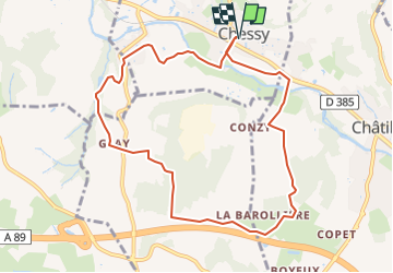

Length
9.6 km

Max alt
391 m

Uphill gradient
253 m
Km-Effort
12.9 km

Min alt
214 m

Downhill gradient
253 m
Boucle
Yes
Creation date :
2021-10-11 18:46:43.0
Updated on :
2024-05-20 19:16:49.682
2h56
Difficulty : Difficult

FREE GPS app for hiking
 SityTrail
IGN / Geographical institutes
SityTrail Plus
The world is yours!
About
Trail Walking of 9.6 km to be discovered at Auvergne-Rhône-Alpes, Rhône, Chessy. This trail is proposed by trietsch.
Positioning
Country:
France
Region :
Auvergne-Rhône-Alpes
Department/Province :
Rhône
Municipality :
Chessy
Location:
Unknown
Start:(Dec)
Start:(UTM)
625866 ; 5082730 (31T) N.
Comments