


j2

dewasseigean
User

Length
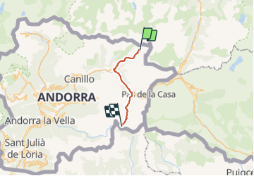
19.4 km

Max alt
2703 m

Uphill gradient
1066 m
Km-Effort
33 km

Min alt
1823 m

Downhill gradient
930 m
Boucle
No
Creation date :
2021-09-29 06:41:53.449
Updated on :
2021-10-12 05:58:17.017
7h31
Difficulty : Very difficult

FREE GPS app for hiking
 SityTrail
IGN / Geographical institutes
SityTrail Plus
The world is yours!
About
Trail Walking of 19.4 km to be discovered at Andorra. This trail is proposed by dewasseigean.
Description
jurcla - montmalus
Positioning
Country:
Andorra
Region :
Unknown
Department/Province :
Unknown
Municipality :
Unknown
Location:
Unknown
Start:(Dec)
Start:(UTM)
394656 ; 4718015 (31T) N.
Comments