


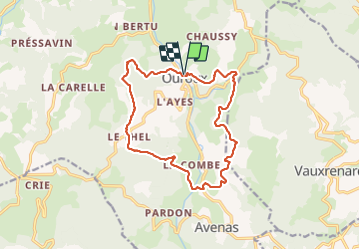
Ouroux (15 km - D. 520 m)

Thomasdanielle
User

Length
14.8 km

Max alt
680 m

Uphill gradient
520 m
Km-Effort
22 km

Min alt
444 m

Downhill gradient
520 m
Boucle
Yes
Creation date :
2021-10-11 07:27:53.0
Updated on :
2021-10-12 10:15:42.014
5h08
Difficulty : Difficult

FREE GPS app for hiking
 SityTrail
IGN / Geographical institutes
SityTrail Plus
The world is yours!
About
Trail Walking of 14.8 km to be discovered at Auvergne-Rhône-Alpes, Rhône, Deux-Grosnes. This trail is proposed by Thomasdanielle.
Description
D/A parking de l'Église
Positioning
Country:
France
Region :
Auvergne-Rhône-Alpes
Department/Province :
Rhône
Municipality :
Deux-Grosnes
Location:
Ouroux
Start:(Dec)
Start:(UTM)
622937 ; 5120988 (31T) N.
Comments