


Les ocres de Mormoiron

soca
User
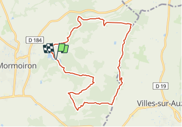

Length
10.2 km

Max alt
378 m

Uphill gradient
231 m
Km-Effort
13.3 km

Min alt
239 m

Downhill gradient
239 m
Boucle
Yes
Creation date :
2021-10-12 12:44:47.617
Updated on :
2021-10-12 12:48:54.029
3h01
Difficulty : Easy

FREE GPS app for hiking
 SityTrail
IGN / Geographical institutes
SityTrail Plus
The world is yours!
About
Trail Walking of 10.2 km to be discovered at Provence-Alpes-Côte d'Azur, Vaucluse, Mormoiron. This trail is proposed by soca.
Positioning
Country:
France
Region :
Provence-Alpes-Côte d'Azur
Department/Province :
Vaucluse
Municipality :
Mormoiron
Location:
Unknown
Start:(Dec)
Start:(UTM)
675931 ; 4881867 (31T) N.
Comments