


Caire Val 3

Berpav
User
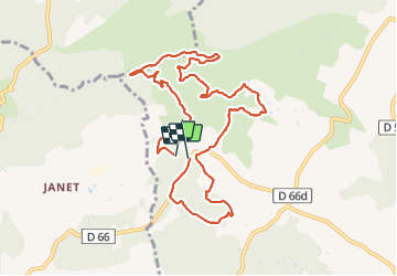

Length
10.8 km

Max alt
476 m

Uphill gradient
264 m
Km-Effort
14.3 km

Min alt
278 m

Downhill gradient
276 m
Boucle
Yes
Creation date :
2021-10-12 11:54:47.409
Updated on :
2021-10-12 14:37:30.964
2h24
Difficulty : Difficult

FREE GPS app for hiking
 SityTrail
IGN / Geographical institutes
SityTrail Plus
The world is yours!
About
Trail Walking of 10.8 km to be discovered at Provence-Alpes-Côte d'Azur, Bouches-du-Rhône, Rognes. This trail is proposed by Berpav.
Positioning
Country:
France
Region :
Provence-Alpes-Côte d'Azur
Department/Province :
Bouches-du-Rhône
Municipality :
Rognes
Location:
Unknown
Start:(Dec)
Start:(UTM)
685956 ; 4839100 (31T) N.
Comments