


bord de Loire saint Sulpice

taguette
User
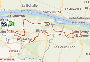

Length
24 km

Max alt
85 m

Uphill gradient
348 m
Km-Effort
29 km

Min alt
17 m

Downhill gradient
347 m
Boucle
Yes
Creation date :
2021-10-13 08:08:53.743
Updated on :
2021-10-13 13:58:36.022
5h12
Difficulty : Very difficult

FREE GPS app for hiking
 SityTrail
IGN / Geographical institutes
SityTrail Plus
The world is yours!
About
Trail Walking of 24 km to be discovered at Pays de la Loire, Maine-et-Loire, Blaison-Saint-Sulpice. This trail is proposed by taguette.
Positioning
Country:
France
Region :
Pays de la Loire
Department/Province :
Maine-et-Loire
Municipality :
Blaison-Saint-Sulpice
Location:
Unknown
Start:(Dec)
Start:(UTM)
694826 ; 5252957 (30T) N.
Comments