Pontlevoy

Pascal Bernaud
User
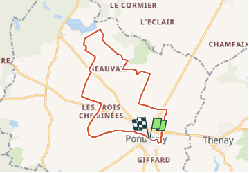

Length
15.6 km

Max alt
116 m

Uphill gradient
74 m
Km-Effort
16.6 km

Min alt
95 m

Downhill gradient
74 m
Boucle
Yes
Creation date :
2021-10-14 06:48:35.0
Updated on :
2021-10-14 09:44:09.586
2h55
Difficulty : Easy

FREE GPS app for hiking
 SityTrail
IGN / Geographical institutes
SityTrail Plus
The world is yours!
About
Trail Walking of 15.6 km to be discovered at Centre-Loire Valley, Loir-et-Cher, Pontlevoy. This trail is proposed by Pascal Bernaud.
Positioning
Country:
France
Region :
Centre-Loire Valley
Department/Province :
Loir-et-Cher
Municipality :
Pontlevoy
Location:
Unknown
Start:(Dec)
Start:(UTM)
368247 ; 5249739 (31T) N.
Comments