


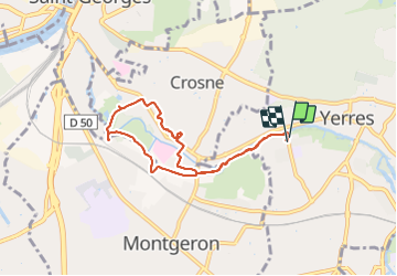
Rando santé Yerres -Crosne

Surot
User

Length
6.7 km

Max alt
40 m

Uphill gradient
31 m
Km-Effort
7.1 km

Min alt
31 m

Downhill gradient
30 m
Boucle
Yes
Creation date :
2021-10-14 07:12:38.0
Updated on :
2021-10-14 10:02:19.303
2h37
Difficulty : Easy

FREE GPS app for hiking
 SityTrail
IGN / Geographical institutes
SityTrail Plus
The world is yours!
About
Trail Walking of 6.7 km to be discovered at Ile-de-France, Essonne, Yerres. This trail is proposed by Surot.
Description
Boucle de 6 à 6,5 km par bords de l’yerres, petite église de Crosne et jardin médiéval
Positioning
Country:
France
Region :
Ile-de-France
Department/Province :
Essonne
Municipality :
Yerres
Location:
Unknown
Start:(Dec)
Start:(UTM)
461673 ; 5395869 (31U) N.
Comments