


bord de Loire le Toureil

taguette
User
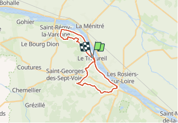

Length
26 km

Max alt
87 m

Uphill gradient
362 m
Km-Effort
30 km

Min alt
19 m

Downhill gradient
361 m
Boucle
Yes
Creation date :
2021-10-14 08:05:32.223
Updated on :
2021-10-14 13:04:11.161
4h56
Difficulty : Very difficult

FREE GPS app for hiking
 SityTrail
IGN / Geographical institutes
SityTrail Plus
The world is yours!
About
Trail Walking of 26 km to be discovered at Pays de la Loire, Maine-et-Loire, Gennes-Val-de-Loire. This trail is proposed by taguette.
Positioning
Country:
France
Region :
Pays de la Loire
Department/Province :
Maine-et-Loire
Municipality :
Gennes-Val-de-Loire
Location:
Unknown
Start:(Dec)
Start:(UTM)
706345 ; 5250020 (30T) N.
Comments