


Pertes de l'Ain

rigol05
User
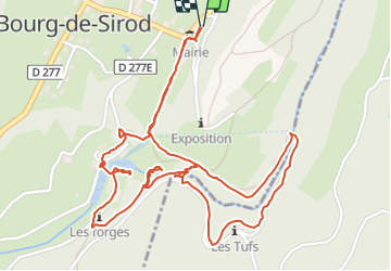

Length
3.7 km

Max alt
608 m

Uphill gradient
93 m
Km-Effort
4.9 km

Min alt
536 m

Downhill gradient
92 m
Boucle
Yes
Creation date :
2021-10-15 10:21:18.684
Updated on :
2021-10-15 10:21:18.684
--
Difficulty : Unknown

FREE GPS app for hiking
 SityTrail
IGN / Geographical institutes
SityTrail Plus
The world is yours!
About
Trail On foot of 3.7 km to be discovered at Bourgogne-Franche-Comté, Jura, Bourg-de-Sirod. This trail is proposed by rigol05.
Positioning
Country:
France
Region :
Bourgogne-Franche-Comté
Department/Province :
Jura
Municipality :
Bourg-de-Sirod
Location:
Unknown
Start:(Dec)
Start:(UTM)
726180 ; 5179233 (31T) N.
Comments