


Ait Bouguemez. Touda

JROYER
User
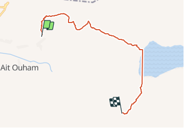

Length
7.4 km

Max alt
2560 m

Uphill gradient
375 m
Km-Effort
11.5 km

Min alt
2212 m

Downhill gradient
90 m
Boucle
No
Creation date :
2021-10-15 08:06:49.71
Updated on :
2021-10-15 13:59:59.318
2h41
Difficulty : Medium

FREE GPS app for hiking
 SityTrail
IGN / Geographical institutes
SityTrail Plus
The world is yours!
About
Trail Walking of 7.4 km to be discovered at Béni Mellal-Khénifra, cercle d'Azilal, Tabant. This trail is proposed by JROYER.
Positioning
Country:
Morocco
Region :
Béni Mellal-Khénifra
Department/Province :
cercle d'Azilal
Municipality :
Tabant
Location:
Unknown
Start:(Dec)
Start:(UTM)
755937 ; 3511766 (29R) N.
Comments