


depart les tavins ,circuit de la jougnena 2021

gerardmicheline
User
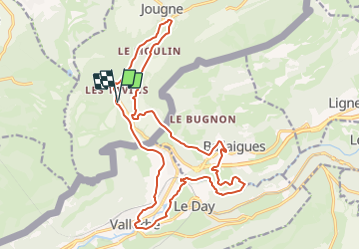

Length
21 km

Max alt
965 m

Uphill gradient
570 m
Km-Effort
28 km

Min alt
631 m

Downhill gradient
567 m
Boucle
Yes
Creation date :
2021-10-16 13:28:29.084
Updated on :
2021-10-16 13:29:33.234
6h23
Difficulty : Very difficult

FREE GPS app for hiking
 SityTrail
IGN / Geographical institutes
SityTrail Plus
The world is yours!
About
Trail Walking of 21 km to be discovered at Bourgogne-Franche-Comté, Doubs, Jougne. This trail is proposed by gerardmicheline.
Positioning
Country:
France
Region :
Bourgogne-Franche-Comté
Department/Province :
Doubs
Municipality :
Jougne
Location:
Unknown
Start:(Dec)
Start:(UTM)
299346 ; 5179733 (32T) N.
Comments