


balav51

JPS73
User
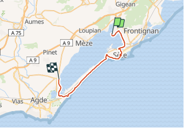

Length
34 km

Max alt
24 m

Uphill gradient
198 m
Km-Effort
37 km

Min alt
-9 m

Downhill gradient
201 m
Boucle
No
Creation date :
2021-10-17 07:42:54.012
Updated on :
2021-10-17 10:40:10.896
2h25
Difficulty : Difficult

FREE GPS app for hiking
 SityTrail
IGN / Geographical institutes
SityTrail Plus
The world is yours!
About
Trail Mountain bike of 34 km to be discovered at Occitania, Hérault, Balaruc-les-Bains. This trail is proposed by JPS73.
Positioning
Country:
France
Region :
Occitania
Department/Province :
Hérault
Municipality :
Balaruc-les-Bains
Location:
Unknown
Start:(Dec)
Start:(UTM)
554525 ; 4810081 (31T) N.
Comments