


Mont Doublier

ETMU5496
User
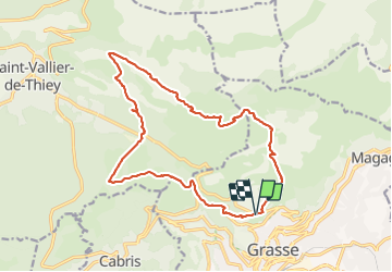

Length
18.9 km

Max alt
1227 m

Uphill gradient
790 m
Km-Effort
29 km

Min alt
527 m

Downhill gradient
793 m
Boucle
Yes
Creation date :
2021-10-17 06:11:19.0
Updated on :
2021-10-23 12:55:34.679
5h13
Difficulty : Medium

FREE GPS app for hiking
 SityTrail
IGN / Geographical institutes
SityTrail Plus
The world is yours!
About
Trail Walking of 18.9 km to be discovered at Provence-Alpes-Côte d'Azur, Maritime Alps, Grasse. This trail is proposed by ETMU5496.
Description
départ parking de l'Empereur
pique-nique sur les crêtes
Photos


Positioning
Country:
France
Region :
Provence-Alpes-Côte d'Azur
Department/Province :
Maritime Alps
Municipality :
Grasse
Location:
Unknown
Start:(Dec)
Start:(UTM)
332215 ; 4836974 (32T) N.
Comments