


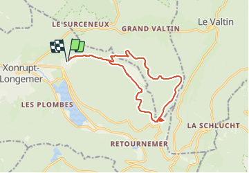
Des Charbonnières à Balveurche, par Belbriette.

Regisconraud
User

Length
14 km

Max alt
1123 m

Uphill gradient
447 m
Km-Effort
20 km

Min alt
759 m

Downhill gradient
459 m
Boucle
Yes
Creation date :
2021-10-17 09:35:20.536
Updated on :
2021-10-17 13:37:37.264
4h01
Difficulty : Easy

FREE GPS app for hiking
 SityTrail
IGN / Geographical institutes
SityTrail Plus
The world is yours!
About
Trail Walking of 14 km to be discovered at Grand Est, Vosges, Xonrupt-Longemer. This trail is proposed by Regisconraud.
Positioning
Country:
France
Region :
Grand Est
Department/Province :
Vosges
Municipality :
Xonrupt-Longemer
Location:
Unknown
Start:(Dec)
Start:(UTM)
347368 ; 5327811 (32U) N.
Comments