


derrière tour crest

ikusen26@gmail.com
User

Length
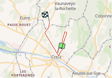
8.2 km

Max alt
406 m

Uphill gradient
325 m
Km-Effort
12.8 km

Min alt
190 m

Downhill gradient
382 m
Boucle
No
Creation date :
2021-10-17 14:01:55.507
Updated on :
2021-10-17 16:27:20.945
2h07
Difficulty : Easy

FREE GPS app for hiking
 SityTrail
IGN / Geographical institutes
SityTrail Plus
The world is yours!
About
Trail Walking of 8.2 km to be discovered at Auvergne-Rhône-Alpes, Drôme, Crest. This trail is proposed by ikusen26@gmail.com.
Positioning
Country:
France
Region :
Auvergne-Rhône-Alpes
Department/Province :
Drôme
Municipality :
Crest
Location:
Unknown
Start:(Dec)
Start:(UTM)
660349 ; 4955102 (31T) N.
Comments